Property Record
Hazel Moon Rd, Winder, GA 30680


Save to a Folder
{{folder.Name}}
{{folder.ListingIds.length}} Properties
{{folder.ListingIds.length}} Property
Create a New Folder
Property Detail
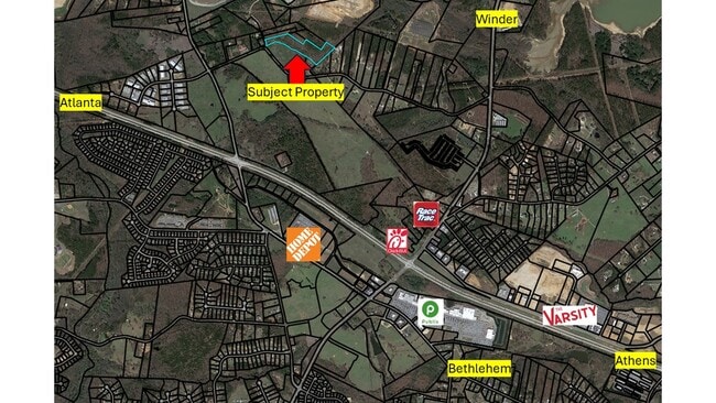
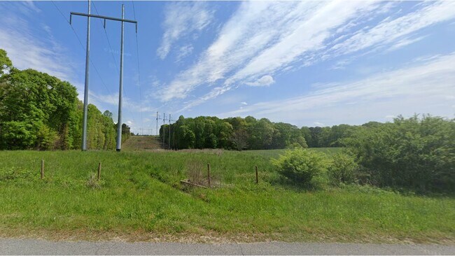
Hazel Moon Rd
XX052-105
HAZEL MOON RD
Residentialacreage
BARROW
AG
Georgia
A Areas with a 1% annual chance of flooding and a 26% chance of flooding over the life of a 30-year mortgage.
9.03 AC
2025
Barrow County
2025
Atlanta
180203
Atlanta-Sandy Springs-Roswell, GA
NEARBY LISTINGS FOR SALE OR LEASE
DEMOGRAPHICS near Hazel Moon Rd
1 mile
3 mile
5 mile
2025 Total Population
2,294
21,717
61,618
2030 Population
2,622
24,609
69,228
Pop Growth 2025-2030
+ 14.30%
+ 13.32%
+ 12.35%
Average Age
35
35
37
2025 Total Households
735
7,192
20,823
HH Growth 2025-2030
+ 14.42%
+ 13.35%
+ 12.45%
Median Household Inc
$89,024
$75,602
$69,285
Avg Household Size
3.10
3.00
2.90
2025 Avg HH Vehicles
2.00
2.00
2.00
Median Home Value
$292,646
$292,161
$292,953
Median Year Built
2005
2004
1999
Nearby Places
Map Layers
Map Styles
 Street
 Aerial
Layers
 Traffic
 Biking
Places
Listings with unknown addresses are not visible on the map
- Restaurants
- Banks
- Shops
- Fitness
- Groceries
Nearby Properties
Address
Land Use
TOTAL SIZE
Lot Size
Zoning
Address
Land Use
TOTAL SIZE
Lot Size
Zoning
1,456 SF
1,732.81 AC
G
Address
Land Use
TOTAL SIZE
Lot Size
Zoning
10,128 SF
28.19 AC
R-3
Address
Land Use
TOTAL SIZE
Lot Size
Zoning
6,424 SF
11.63 AC
B-2,R-3
Address
Land Use
TOTAL SIZE
Lot Size
Zoning
420,876 SF
26.84 AC
M-2
Address
Land Use
TOTAL SIZE
Lot Size
Zoning
26,789 SF
35.64 AC
C-3
Address
Land Use
TOTAL SIZE
Lot Size
Zoning
165,737 SF
124.90 AC
G
Address
Land Use
TOTAL SIZE
Lot Size
Zoning
22,320 SF
15.90 AC
R-3
Address
Land Use
TOTAL SIZE
Lot Size
Zoning
120,000 SF
142.73 AC
AG
Address
Land Use
TOTAL SIZE
Lot Size
Zoning
305,327 SF
22.05 AC
M-2
Address
Land Use
TOTAL SIZE
Lot Size
Zoning
690,427 SF
156.03 AC
M-1
Address
Land Use
TOTAL SIZE
Lot Size
Zoning
301,200 SF
39.18 AC
M-2
Address
Land Use
TOTAL SIZE
Lot Size
Zoning
2,046 SF
12.97 AC
B-2,R-3
Address
Land Use
TOTAL SIZE
Lot Size
Zoning
167,580 SF
21.82 AC
M-2
Address
Land Use
TOTAL SIZE
Lot Size
Zoning
37,012 SF
10.55 AC
OI
Address
Land Use
TOTAL SIZE
Lot Size
Zoning
183,060 SF
17.90 AC
M-2
Address
Land Use
TOTAL SIZE
Lot Size
Zoning
89,684 SF
64.92 AC
B-2
Address
Land Use
TOTAL SIZE
Lot Size
Zoning
104,805 SF
12.54 AC
C-3
Address
Land Use
TOTAL SIZE
Lot Size
Zoning
89,520 SF
13.99 AC
M-2
Address
Land Use
TOTAL SIZE
Lot Size
Zoning
189,400 SF
24.79 AC
C-2
Address
Land Use
TOTAL SIZE
Lot Size
Zoning
233,462 SF
25.22 AC
C-2
Address
Land Use
TOTAL SIZE
Lot Size
Zoning
2,398 SF
8.13 AC
R-3
Address
Land Use
TOTAL SIZE
Lot Size
Zoning
132,156 SF
10.05 AC
C-2
Address
Land Use
TOTAL SIZE
Lot Size
Zoning
1,188 SF
7.63 AC
R-3
Address
Land Use
TOTAL SIZE
Lot Size
Zoning
79,029 SF
9.72 AC
C-2
Address
Land Use
TOTAL SIZE
Lot Size
Zoning
64,800 SF
47.27 AC
M-1
Address
Land Use
TOTAL SIZE
Lot Size
Zoning
3,370 SF
352.38 AC
G,TNPD
Address
Land Use
TOTAL SIZE
Lot Size
Zoning
60,540 SF
79.35 AC
AG
Address
Land Use
TOTAL SIZE
Lot Size
Zoning
38,550 SF
3.04 AC
C-2
Address
Land Use
TOTAL SIZE
Lot Size
Zoning
37,162 SF
4.62 AC
R-3
Address
Land Use
TOTAL SIZE
Lot Size
Zoning
55,420 SF
5.05 AC
C-3
The World's #1 Commercial Real Estate Marketplace
Connect with us
© 2026 CoStar Group
The information above has been obtained from sources believed reliable. While we do not doubt its accuracy we have not verified it and make no guarantee, warranty or representation about it. It is your responsibility to independently confirm its accuracy and completeness. Any projections, opinions, assumptions, or estimates used are for example only and do not represent the current or future performance of the property. The value of this transaction to you depends on tax and other factors which should be evaluated by your tax, financial, and legal advisors. You and your advisors should conduct a careful, independent investigation of the property to determine to your satisfaction the suitability of the property for your needs.